9.24.2022
The Cultural History of Godzilla – Pt 9


P 24
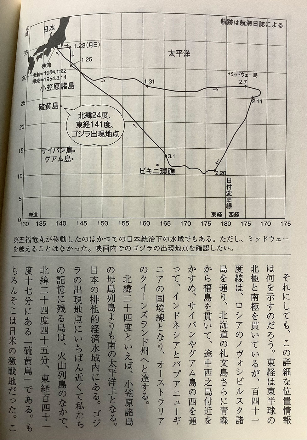
Chart
航跡は航海日誌による
The trajectory is according to the logbook
日本 Japan
1.23(月) 1.23 (Mon)
太平洋 Pacific Ocean
出航 (Departure) = 154.3.14 -1954.1.22 1954.3
小笠原諸島 Ogasawara Islands
ミッドウェー島 Midway Island
北緯24度、東経141度、ゴジラ出現地点
24 degrees north latitude, 141 degrees east longitude, Godzilla appearance point
サイパン島 Saipan Island
グアム島 Guam
ビキニ環礁 Bikini Atoll
日付変更線 Date Line
東経 East longitude
西経 West longitude
赤道 Equator
Caption
第五福竜丸が移動したのはかつての日本統治下の水域でもある。ただし、ミッドウェーを越えることはなかった。映画内でのゴジラの出現地点を確認したい。
The Daigo Fukuryu Maru moved to waters that were once under Japanese rule. However, it never crossed Midway. I want to confirm the appearance point of Godzilla in the movie.
それにしても、この詳細な位置情報は何を示すのだろう。東経は東半球の北極と南極を貫いているが、百四十一度線は、ロシアのノヴォシビルスク諸島を通り、北海道の礼文島さらに青森から福島を貫いて、途中西之島付近を かすめ、サイパンやグアム島の西を通って、インドネシアとパプアニューギニアの国境線となり、オーストラリアのクイーンズランド州へと達する。
But what does this detailed location information tell us? The east longitude runs through the North and South Poles of the eastern hemisphere, but the 141st line runs through the Novosibirsk Islands in Russia, through Rebun Island in Hokkaido, through Aomori and Fukushima, passing through Nishinoshima and Saipan on the way. and west of Guam, forming the border between Indonesia and Papua New Guinea, and ending in Queensland, Australia.

P 25
北緯二十四度といえば、小笠原諸島の母島列島よりも南の太平洋上となる。日本の排他的経済水域内にある。ゴジラの出現地点にいちばん近くて私たちの記憶に残る島は、火山列島のなかで、北緯二十四度四十五分、東経百四十一十七分にある「硫黄島」である。もちろんそこは日米の激戦地だった。このことから、ゴジラを南方戦線で失意のまま死んだ「英霊」とみなす解釈が生まれてきた。
Speaking of 24 degrees north latitude, it is on the Pacific Ocean south of the Hahajima Islands of the Ogasawara Islands. It is within Japan’s exclusive economic zone. The island closest to Godzilla’s appearance in our memory is Iwo Jima, in the volcanic archipelago, at 24 degrees 45 minutes north latitude and 1417 minutes east longitude. Of course, it was the site of a fierce battle between Japan and the United States. This has led to the interpretation that Godzilla is regarded as a “hero” who died in despair on the Southern Front.
硫黄島のはるか南にはB2などの出撃基地となったグアムやサイパンがあり、南東の南鳥島の延長上には水爆実験のビキニ環礁のあるマーシャル諸島がある。観客は今よりもずっと南洋の島々の名前を覚えていたはずだ。南洋諸島はずっと日本の統治下にあったし、硫黄島をはじめとして、グアムやサイパンなど戦地として名前が記憶されている。ビキニ環礁さえも玉砕地だったのだ。焼津港を出た第五福竜丸は、ミッドウェーの南を通り、マーシャル諸島を抜けて、ウェーク島の南や南鳥島の近く を通って戻ってきた。こうした島の位置を頭で描ける人たちが観客のなかにまだたくさんいたのだ。
To the far south of Iwo Jima are Guam and Saipan, which served as sortie bases for the B2, etc., and on the extension of Minamitorishima to the southeast are the Marshall Islands, where the hydrogen bomb test was conducted on Bikini Atoll. The audience would have remembered the names of the South Sea islands much better than they do now. The South Sea Islands have been under Japanese rule for a long time, and their names are remembered as battlefields such as Iwo Jima, Guam and Saipan. Even Bikini Atoll was a precious land. After leaving Yaizu Port, the Daigo Fukuryu Maru passed south of Midway, through the Marshall Islands, south of Wake Island and near Minamitorishima before returning. There were still many people in the audience who could picture the location of these islands in their minds.
明神礁と洞爺丸台風
Myojin Reef and Toyamaru Typhoon
ゴジラは途中にどんな障害物があっても直進してくるように見える。人間が作る防衛線などあっさ超えるし、通常兵器をまったくものともしない。これこそが怪獣特撮物のだいご味といえるが、こうしたゴジラの動きは交渉や誘導の余地がない自然現象に近い印象を与える。それがゴジラがもつ怖さや不気味さの源となっているのは確かだ。
Godzilla seems to go straight ahead no matter what obstacles are in his way. It easily crosses the line of defense created by humans, and is completely immune to conventional weapons. This can be said to be the main flavor of monster special effects, but such movements of Godzilla give the impression of a natural phenomenon with no room for negotiation or guidance. It is certain that this is the source of Godzilla’s fear and spookiness.
最初に栄光丸がやられたときに、「明神礁のときとおなじだ」と海上保安庁の職員が口にする。これは一九五二年に起きた明神礁の爆発を指している。明神礁の位置は北緯三十二度十分、東経百四十五分で、ゴジラ出現の場所よりはずっと本土に近かった。
When Eiko Maru was first hit, an official of the Japan Coast Guard said, “It’s the same as Myojinjo.” This refers to the Myojin Reef explosion that occurred in 1952. Myojin Reef was located at 32 degrees 10 minutes north latitude and 145 minutes east longitude, much closer to the mainland than the place where Godzilla appeared.